


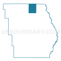
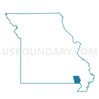
Oak Brier Voting District, Butler County, Missouri
About
Outline

Summary
| Unique Area Identifier | 607261 |
| Name | Oak Brier Voting District |
| County | Butler County |
| State | Missouri |
| Area (square miles) | 20.11 |
| Land Area (square miles) | 20.03 |
| Water Area (square miles) | 0.08 |
| % of Land Area | 99.61 |
| % of Water Area | 0.39 |
| Latitude of the Internal Point | 36.88553580 |
| Longtitude of the Internal Point | -90.38033610 |
Maps

Graphs
Select a template below for downloading or customizing gragh for Oak Brier Voting District, Butler County, Missouri


Neighbors
Neighoring Voting District (by Name) Neighboring Voting District on the Map
- Chaonia Voting District, Wayne County, MO
- Hendrickson Voting District, Butler County, MO
- Lake Road Voting District, Butler County, MO
- Wappapello Voting District, Butler County, MO
Top 10 Neighboring County Subdivision (by Population) Neighboring County Subdivision on the Map
- Poplar Bluff township, Butler County, MO (25,878)
- St. Francois township, Butler County, MO (1,794)
- Black River township, Butler County, MO (1,665)
- Black River township, Wayne County, MO (711)
Top 10 Neighboring Unified School District (by Population) Neighboring Unified School District on the Map
- Poplar Bluff R-I School District, MO (32,169)
- Twin Rivers R-X School District, MO (5,956)
- Greenville R-II School District, MO (5,601)